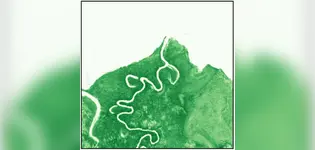
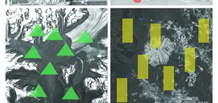
Machine learning analysis of satellite imagery is revolutionizing environmental assessments by significantly reducing field costs and enhancing regulatory certainty. This technology allows for large-scale ecosystem analysis without the need for costly field crews, addressing vital issues like vegetation health and habitat connectivity. Environmental consulting firms, particularly AJM Environmental Inc., are leveraging these advancements to promote responsible development practices.
The application of satellite data extends beyond mere observation; it includes sophisticated techniques like the Normalized Difference Vegetation Index (NDVI) to assess vegetation health. AJM employs machine learning methods such as random forests and gradient boosting to predict vegetation stress and classify land cover with high accuracy. As satellite imagery technology evolves, the potential for addressing complex ecological challenges at scale continues to grow, positioning AJM at the forefront of this innovative field.
Isomorphic Labs, the AI drug discovery platform that was spun out of Google's DeepMind in 2021, has raised external capital for the first time. The $600
How to level up your teaching with AI. Discover how to use clones and GPTs in your classroom—personalized AI teaching is the future.
Trump's Third Term? AI already knows how this can be done. A study shows how OpenAI, Grok, DeepSeek & Google outline ways to dismantle U.S. democracy.
Sam Altman today revealed that OpenAI will release an open weight artificial intelligence model in the coming months. "We are excited to release a powerful new open-weight language model with reasoning in the coming months," Altman wrote on X.